|
News and Events from One Tam
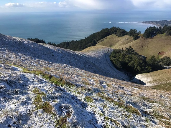
Mt. Tam dusted with snow during a recent storm. Photo courtesy of Mount Tamalpais State Park.
Hello!
It's been a wild and wet winter on Mt. Tam, resulting in very full lakes and reservoirs, spectacular waterfalls and creeks flowing like river rapids. The strong rains bring excitement and beauty, but can result in dangerous situations. We hope your friends and family have remained safe and sound.
What have you seen on and around the mountain during the recent storms? Use #OneTam on Instagram and show us the Tam that you see and experience. And follow us at @OneTamalpais.
Take a look at the events we have lined up for you. And learn about what big plans the One Tam initiative has for the next 5 years. There’s a lot happening on the mountain and with the people who care about it. We hope you’ll join us!
~ Your friends at One Tam

Last Call for LINC Applications!
March 10 is the deadline for One Tam's high school summer program!
Do you know a high school student interested in building leadership skills, making friends, and learning career skills? Linking Individuals to their Natural Community (LINC) might be the perfect fit this summer!
The Next Five Years
This year One Tam will celebrate five years of growth, community building, and deep learning. The incredible Marin community has helped make this work possible, and the One Tam partners are excited to share with you a plan for the next five years of supporting our beloved mountain, together.
The next five years will focus on sustaining our partnership, fostering a healthy and climate-resilient of Mt. Tam, and engaging new audiences in our work through diversity, equity and inclusion efforts. For example, we will:
- Continue to collect data, including expanding community science opportunities, to improve our understanding of the mountain’s health and put our knowledge to work on the ground.
- Advance projects that restore the mountain’s lands and waters, and integrate them with our stewardship, youth, and science work.
- Launch a volunteer-based trail stewardship program to improve trails and protect landscapes.
- Deepen community connections through strengthening our stewardship, youth, and community science, and engagement programs.
Read the plan and get inspired for the next 5 years of One Tam...
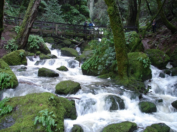
Photo by Carl Sanders.
Seeps and Springs of Mt. Tam
Catch the last lecture in Marin Art & Garden Center’s annual Conservation Series – Health of the Mountain!
Hear what we’ve learned from a new inventory of Mt. Tam’s seeps and springs, part of an ongoing effort to understand the health of the mountain. We’ll tie these local findings to broader conditions, and get the latest consensus on climate change and what needs to be done.
We will be hearing from Jake Kurzweil, a San Anselmo local and PhD student at Colorado School of Mines studying hydrologic science. He'll share his recent work on Mt. Tam seeps and springs. Also joining us is Ellie Cohen, another San Anselmo local, recently retired from a 20-year career as President and CEO of Point Blue Conservation Science, where she was a leader and catalyst for finding and implementing collaborative, nature-based solutions to climate change and environmental design.
Thursday, March 14, 6-8 pm in the Studio
Marin Art and Garden Center
Get tickets here...
![]()
Tam's Wild Side Returns
After three years and four million images, the Marin Wildlife Picture Index Project is excited to release its first findings! Marin Art & Garden Center is teaming up with One Tam to offer a glimpse of what we’re learning about our wild neighbors. Plus you’ll get to enjoy a happy hour with biologists, staff, and community scientists working to understand the health of Mt. Tam’s wildlife.
Marin Wildlife Picture Index Project, The First Three Years
Friday, April 12, 6pm
Livermore Pavilion, Marin Art and Garden Center
Find tickets here...
Outside and Moving on the Mountain
Lend Plants a Hand
Help remove a fast-growing weed with beautiful views of the Pacific at Bolinas Ridge.
Saturday, March 9, 9 am–Noon
Mt. Tam West Peak Hike
Join filmmaker Gary Yost and Marin Municipal Water District ranger Matt Cerkel on Mt. Tam for a special talk about the true peak of our beloved mountain.
Saturday, March 16, 10 am–1:30 pm
Help Restore Creekside Marsh
Enjoy dreamy views of Mt. Tam while removing invasive plants and planting natives!
Saturday, March 16, 9 am-Noon
Easkoot Creek Restoration
Help improve the coho salmon habitat in the streams at Stinson Beach.
Saturday, March 23, 9 am-Noon
Wildlife Picture Index Workshop
Ooh and ahh at the Mt. Tam animals at the Marin Wildlife Picture Index Project workshop! People like you serve as “Community Scientists” to view and catalog photos on the computer captured from our wildlife cameras.
Tuesday, March 26, 1-4 pm
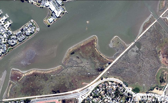
An aerial photo of Bothin Marsh Open Space Preserve.
Taking Flight to See the Land
We can’t take care of what we don’t know.
The Marin Countywide Vegetation Map project is going to change that for the county’s plants and habitats. This collaborative effort of the One Tam partners and Marin County’s scientific and land management communities is creating the first surveys of the entire county's topography, built and natural features, and diverse plant communities and habitats. The resulting maps and underlying data will be used to understand and coordinate management of fire and flood hazards, critical habitats, and climate change resiliency.
The project is using a unique interdisciplinary approach that combines on-the-ground field data collection and vegetation sampling with remote sensing and high-resolution aerial imagery. Put all together, this information can be used to create very fine scale and accurate maps.
The first big piece of the project is now complete.
High resolution aerial imagery for the entire county was taken in June of 2018 and is being released this month. Flights over key coastal, bay, and lagoon areas were timed to coincide with low tide conditions so that the images could capture wetland/emergent vegetation and tidal marsh areas. During the quality control process, the project team identified several opportunities to expand the bay and lagoon areas covered in the final aerial photos.
Learn more…
A New Look for One Tam
Introducing the new-and-improved ONETAM.ORG! Our new site makes it easier than ever to stay informed about One Tam happenings and new and exciting ways to get involved. And don’t forget to check our new calendar to sign up for opportunities from One Tam and partners!
About One Tam
One Tam seeks to raise awareness about the need to maintain the long-term health of Mt. Tam, engage more volunteers in caring for its treasured resources, and renew the spirit of philanthropy that has been so fundamental to the preservation of Mt. Tam over the past century.
Donate Today!
|